Aberystwyth

Wales · Ceredigion · Wales

Walks from Aberystwyth, Ceredigion

📍 Wales
🌿 Coastal cliff, river valley, moorland, farmland
0 routes available
⛰ Easy to Challenging
Free to access

🥾0 RoutesAvailable
⛰Easy to ChallengingDifficulty
📅April–OctoberBest Months
🚗AberystwythStart Point

Aberystwyth is mid-Wales’s main town — a lively, slightly eccentric university settlement on a wide bay between two headlands, with the Wales Coast Path threading through and the Rheidol Valley climbing into the hills behind. Constitution Hill above the town gives wide views along the Cardigan Bay coastline.

A useful and lively base for mid-Wales walking, Aberystwyth has a good range of accommodation and restaurants as well as a direct rail link from Shrewsbury. The Vale of Rheidol railway to Devil’s Bridge is one of the finest narrow-gauge journeys in Wales.

All Routes

0 Walks from Aberystwyth

Sorted by popularity
Minions
Author Image

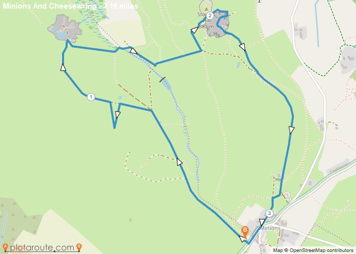
Minions via Cheesewring Quarry and Stowes Hill

Portwrinkle
Author Image

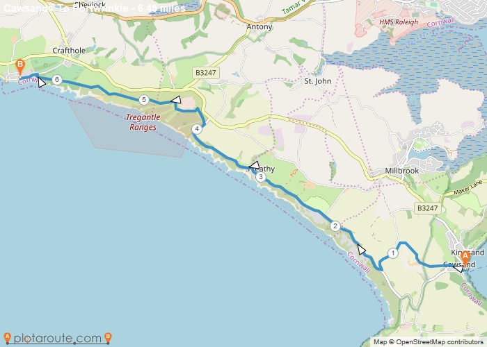
Cawsands To Portwrinkle via South West Coast Path Walk

England
Author Image

Kingley Vale around the Nature Reserve, West Sussex

Author Image

Winchester via St Catherines Hill, Hampshire

Author Image

Winchester via Chilcomb and River Itchen

Fishbourne
Author Image

Fishbourne via Bosham West Sussex – 9.4 Circular Mile Walk

Author Image

Hindhead Devils Punch Bowl – 4.8 Mile Circular Walk

Devon
Author Image

Seaton Devon to Seatown Dorset via South West Coast Path 15 Mile Walk

Devon
Author Image

Sidmouth to Seaton via South West Coast Path

Devon
Author Image

Exmouth to Sidmouth via South West Coast Path

Babbacombe
Author Image

Babbacombe to Exmouth via South West Coast Path

Babbacombe
Author Image

Brixham to Babbacombe via South West Coast Path

Cornwall
Author Image

Portwrinkle to Plymouth via South West Coast Path

Coastal Walks
Author Image

Polperro to Portwrinkle via South West Coast Path

Coastal Walks
Author Image

Par to Polperro via South West Coastal Path

Coastal Walks
Author Image

Marazion to Porthleven via South West Coastal Path

Coastal Walks
Author Image

St Ives to Pendeen via South West Coast Path

Coastal Walks
Author Image

Newquay to Perranporth via South West Coast Path

Coastal Walks
Author Image

Porthcothan to Newquay – South West Coastal Path

Coastal Walks
Author Image

Padstow to Porthcothan via South West Coast Path

At a Glance

Walks available0 routes
DifficultyEasy to Challenging
Best monthsApril–October
TerrainCoastal cliff, river valley, moorland, farmland
CountyCeredigion
Dogs welcome✓ Yes

Getting There

📍
Aberystwyth, Ceredigion
Open in Google Maps

Town centre car parks. Train from Shrewsbury. Aberystwyth station (Cambrian Coast line from Shrewsbury)

Food & Drink

Ultracomida, Gwesty Cymru hotel restaurant, The Glengower Hotel

Notable Walks Nearby

  • Constitution Hill
  • Wales Coast Path north to Borth
  • Rheidol Valley walk
  • Devil’s Bridge
  • Aberystwyth to Clarach Bay
  • Pumlumon approach
  • All Ceredigion towns →

🗺 OS Map Reference

Walking around Aberystwyth is covered by OS Explorer 213 / 214. Recommended for all routes in this area.

View OS Map Guide

Long Distance Trails Nearby

  • Wales Coast Path
  • Cambrian Way
  • Glyndŵr’s Way

Scroll to Top