England · Shropshire Hills National Landscape
Walking in Shropshire
Discover walking trails across Shropshire — from coastal paths and national parks to quiet village routes and open moorland.
20+ Routes
16 Starting Towns
Free All Routes
Filter: All Coastal Moorland Circular Easy Moderate Challenging Under 5 miles 5–10 miles 10+ miles
Shropshire is shaped by the Shropshire Hills, including the Long Mynd and Wenlock Edge, with the Shropshire Way and Offa’s Dyke Path both passing through the county along the Welsh border.
Starting Points
All Starting Towns in Shropshire
Distance: 4.7 Miles Time: 2 hours 16 minutes Elevation: 666 Feet Terrain: Mixed Start Point: Wentnor End Point: Wentnor null
Distance:
Starting Point:
Terrain Type:
Elevation:
OS Map:
Walking Time:
Distance: 1.3 Miles Time: 35 minutes Elevation: 52 Feet Terrain: Mixed Start Point: Shrewsbury End Point: Shrewsbury null OS Maps
Distance:
Starting Point:
Terrain Type:
Elevation:
OS Map:
Walking Time:
Distance: 4.3 Miles Time: 1 hour 52 minutes Elevation: 279 Feet Terrain: Mixed Start Point: Shifnal End Point: Shifnal null
Distance:
Starting Point:
Terrain Type:
Elevation:
OS Map:
Walking Time:
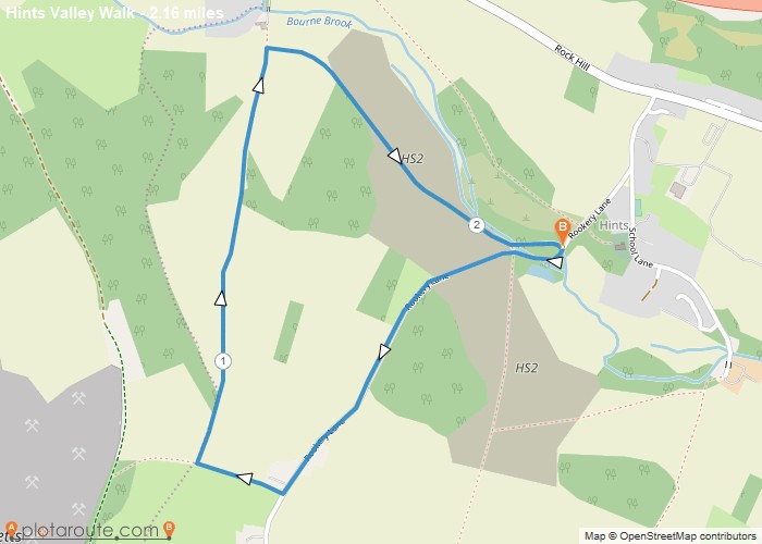
Distance: 2.2 Miles Time: 1 hour 03 minutes Elevation: 210 Feet Terrain: Mixed Start Point: Hints End Point: Hints null
Distance:
Starting Point:
Terrain Type:
Elevation:
OS Map:
Walking Time:
Distance: 4.6 Miles Time: 2 hours 11 minutes Elevation: 39 Feet Terrain: Road Start Point: Cressage End Point: Cressage null
Distance:
Starting Point:
Ending Point:
Terrain Type:
Elevation:
OS Map:
Walking Time:
Distance: 2.0 Miles Time: 51 minutes Elevation: 889 Feet Terrain: Road Start Point: Shrewsbury End Point: Shrewsbury null OS Maps
Distance:
Starting Point:
Terrain Type:
Elevation:
OS Map:
Walking Time:
Distance: 2.9 Miles Time: 1 hour 16 minutes Elevation: 472 Feet Terrain: Off-Road Start Point: Shifnal End Point: Shifnal null
Distance:
Starting Point:
Terrain Type:
Elevation:
OS Map:
Walking Time:
Distance: 4.9 Miles Time: 2 hours 21 minutes Elevation: 571 Feet Terrain: Off-Road Start Point: Much Wenlock End Point: Much
Distance:
Starting Point:
Ending Point:
Terrain Type:
Elevation:
OS Map:
Walking Time:
Distance: 4.6 Miles Time: 2 hours 07 minutes Elevation: 492 Feet Terrain: Mixed Start Point: Ludlow End Point: Ludlow null
Distance:
Starting Point:
Ending Point:
Terrain Type:
Elevation:
OS Map:
Walking Time:
Distance: 4.1 Miles Time: 2 hours 20 minutes Elevation: 1040 Feet Terrain: Off-Road Start Point: Ludlow End Point: Ludlow null
Distance:
Starting Point:
Terrain Type:
Elevation:
OS Map:
Walking Time:
Distance: 4.7 Miles Time: 2 hours 15 minutes Elevation: 3153 Feet Terrain: Off-Road Start Point: Hopton Wafers End Point: Hopton
Distance:
Starting Point:
Terrain Type:
Elevation:
OS Map:
Walking Time:
Distance: 4.1 Miles Time: 2 hours 15 minutes Elevation: 1040 Feet Terrain: Off-Road Start Point: Cleeton St Mary End Point:
Distance:
Starting Point:
Terrain Type:
Elevation:
OS Map:
Walking Time:
Distance: 4.4 Miles Time: 1 hour 59 minutes Elevation: 2251 Feet Terrain: Off-Road Start Point: Cheswardine End Point: Cheswardine null
Distance:
Starting Point:
Ending Point:
Terrain Type:
Elevation:
OS Map:
Walking Time:
Distance: 3.3 Miles Time: 1 hour 27 minutes Elevation: 440 Feet Terrain: Off-Road Start Point: Bicton End Point: Bicton null
Distance:
Starting Point:
Terrain Type:
Elevation:
OS Map:
Walking Time:
Distance: 7.8 Miles Time: 3 hours 27 minutes Elevation: 636 Feet Terrain: Mixed Start Point: Whitchurch End Point: Whitchurch A moderately
Distance:
Starting Point:
Ending Point:
Terrain Type:
Elevation:
OS Map:
Walking Time:
Distance: 15.0 Miles Time: 6 hours 53 minutes Elevation: 1824 Feet Terrain: Mixed Start Point: Whitchurch End Point: Whitchurch A moderately
Distance:
Starting Point:
Ending Point:
Terrain Type:
Elevation:
OS Map:
Walking Time:
7.3 mile circular walking route starting from Longnor via Hollinsclough, High Edge, Chrome Hill and Parkhouse Hill in the Peak
Distance:
Starting Point:
Ending Point:
Terrain Type:
Elevation:
OS Map:
Walking Time:
7.6 mile circular walking trail starting from Church Stretton in Shropshire. Distance: 7.6 milesTime: 3 hoursElevation: 1505 footTerrain: foot paths
Distance:
Starting Point:
Ending Point:
OS Map:
5 mile circular walking trail from Clun in Shropshire. Distance: 5 milesTime: 1 hoursElevation: 1013 footTerrain: foot paths and tracks.Map:
Distance:
OS Map:
6.9 Mile Circular walk starting from EllesmereNd via the mere pond, ellesmere point in Shropshire. Distance: 6.9 milesTime: 3 hoursElevation:
Distance:
Starting Point:
Ending Point:
OS Map:
Hand Picked
Highlighted Walks in Shropshire
No walks published in Shropshire yet -- check back soon.
Planning a Long Distance Walk in Shropshire?
Explore our guides to long distance trails passing through Shropshire, with stage-by-stage route information.
All Long Distance Trails