Wales · Powys · Wales
Walks from Llanidloes, Powys
📍 Wales
🌿 Upland forest, mountain moorland, reservoir shore, river valley
0 routes available
⛰ Easy to Challenging
Free to access
🌿 Upland forest, mountain moorland, reservoir shore, river valley
0 routes available
⛰ Easy to Challenging
Free to access
🥾0 RoutesAvailable
⛰Easy to ChallengingDifficulty
📅May–SeptemberBest Months
🚗LlanidloesStart Point
Llanidloes is the first town on the River Severn — a handsome half-timbered market town with a remarkable medieval market hall in its centre, at the edge of the vast Hafren Forest. The source of the Severn on the slopes of Plynlimon is within a day’s walk, and Glyndŵr’s Way passes through.
A lovely, quietly flourishing small town with independent shops, a food festival and the only remaining medieval market hall in Wales, Llanidloes is a very characterful base for some of the most remote walking in mid Wales.
All Routes
0 Walks from Llanidloes
Sorted by popularity
England
Favourite
Distance: 6.6 Miles Time: 3 hours 15 minutes Elevation: 623 Feet Terrain: Road Start Point: Northowram End Point: Northowram null
Distance: 6.6 miles
Starting Point: Northowram
Terrain Type: Road
Elevation: 623 Feet
OS Map: OS Explorer
Walking Time: 3 hours 15 minutes
Interactive Map:
Distance: 3.9 Miles Time: 1 hour 38 minutes Elevation: 92 Feet Terrain: Mixed Start Point: Frisby on the Wreake End
Distance: 3.9 miles
Starting Point: Frisby on the Wreake
Ending Point: Frisby on the Wreake
Terrain Type: Mixed
Elevation: 92 Feet
OS Map: OS Explorer
Walking Time: 1 hour 38 minutes
Interactive Map:
Distance: 6.5 Miles Time: 2 hours 45 minutes Elevation: 2139 Feet Terrain: Mixed Start Point: Rushford End Point: Rushford null
Distance: 6.5 miles
Starting Point: Rushford
Terrain Type: Mixed
Elevation: 2139 Feet
OS Map: OS Explorer
Walking Time: 2 hours 45 minutes
Interactive Map:
Cumbria
Favourite
Distance: 18.9 Miles Time: 11 hours 48 minutes Elevation: 2444 Feet Terrain: Off-Road Start Point: Lowick Green End Point: Lowick
Distance: 18.9 miles
Starting Point: Lowick Green
Terrain Type: Off-Road
Elevation: 2444 Feet
OS Map: OS Explorer
Walking Time: 11 hours 48 minutes
Interactive Map:
7.2 Mile circular walk starting from Surprise View via Holy Wood and Over Owler Tor A hilly circular walking route, mostly off-road, approximately 7.2 miles long.
Distance: 7.2 miles
Starting Point: Surprise View Car Park A6187 Grindleford Dales
Ending Point: Surprise View Car Park A6187 Grindleford Dales
Terrain Type: Mixed
Elevation: 1138 Feet
OS Map: OS Explorer
Walking Time: 3 hours 40 minutes
Interactive Map:
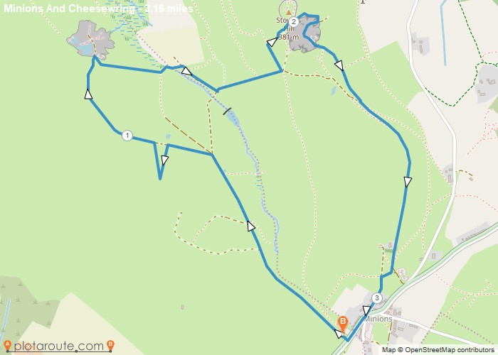
3.2 Miles circular walk from Minions via Cheesewring Quarry and Stowes Hill Walk 18 Cornish Teashop walks OS Maps Required
Distance: 3.2 miles
Starting Point: The Hurlers Car Park Grasmere Lane Minions Linkinhorne
Ending Point: The Hurlers Car Park Grasmere Lane Minions Linkinhorne
Terrain Type: Off-Road
Elevation: 1427 Feet
OS Map: OS Explorer
Walking Time: 1 hour 30 minutes
Interactive Map:
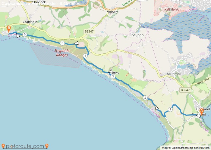
6 mile walk from Cawsands to Portwrinkle via South West Coast Path. Distance: 6.4 Miles Time: 3 hours 08 minutes
Distance: 6.4 miles
Starting Point: Kingsand
Ending Point: Portwrinkle
Terrain Type: Off-Road
Elevation: 463 Feet
OS Map: OS Explorer
Walking Time: 3 hours 08 minutes
Interactive Map:
Bramley
Favourite
5 mile walking route starting from Bramley following the disused railway to Cranleigh. Distance: 5 miles Time: 1.5 hours Elevation: 294 foot Terrain:
Distance: 5 miles
Starting Point: Bramley
Terrain Type: footpaths and tracks.
Elevation: 294 Feet
OS Map: OS Explorer
Walking Time: 1.5 hours
Interactive Map:
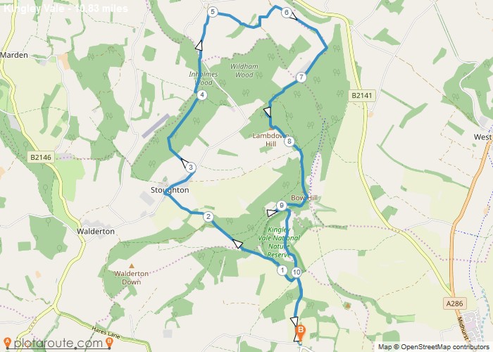
10.8 mile circular walk from West Stoke car park in West Sussex Distance: 10.8 milesTime: 3.5 hoursElevation: 400 footTerrain: footpaths
Distance: 10.8 miles
Starting Point: Kingley Vale Car Park West Sussex
Ending Point: Stoughton
Terrain Type: Downland ancient woodland and open hillside
Elevation: 400 Feet
OS Map: OS Explorer
Walking Time: 3.5 hours
Interactive Map:
NULL
Rowlands Castle
Favourite
6.2 mile circular walk from Rowlands Castle in Hampshire via Staunton Country Park and the Havant Thicket. Distance: 6.2 miles
Distance: 6.2 miles
Starting Point: Rowlands Castle Train Station Hampshire
Ending Point: Rowlands Castle Train Station Hampshire
Terrain Type: footpaths and tracks.
Elevation: 337 Feet
OS Map: OS Explorer
Walking Time: 2.5 hours
Interactive Map:
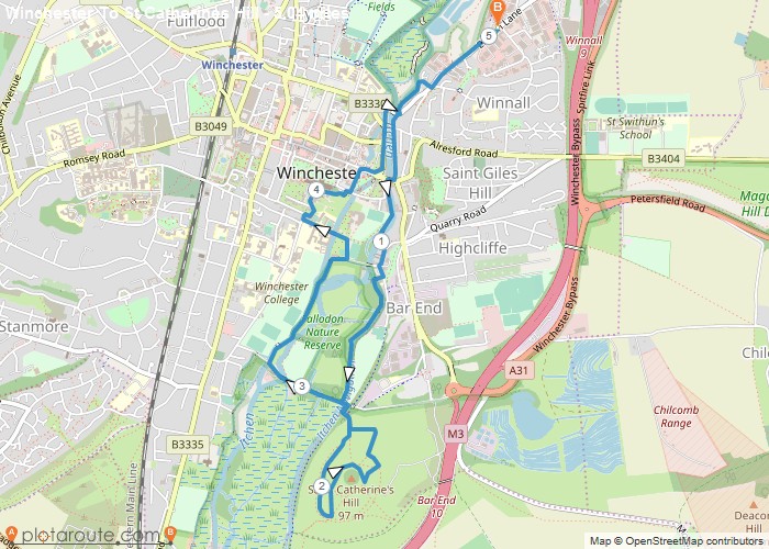
5 mile circular walk starting from Winchester via St Catherines Hill in Hampshire. Distance: 5 Miles Time: 1.5 hours Elevation:
Distance: 5 miles
Starting Point: Winchester Car Park
Ending Point: Winchester Car Park
Terrain Type: Riverside meadows and small hilltop
Elevation: 230 Feet
OS Map: OS Explorer
Walking Time: 1.5 hours
Interactive Map:
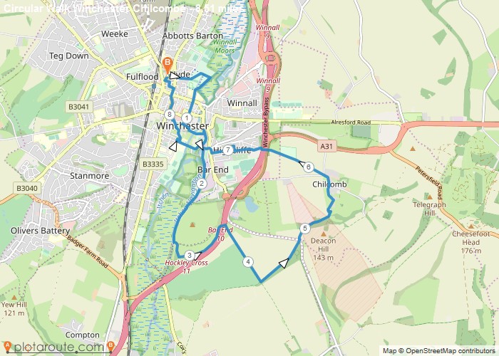
8.5 mile circular walk starting from Winchester via St Catherines Hill and Chilcombe in Hampshire. Distance: 8.5 milesTime: 3 hoursElevation:
Distance: 8.5 miles
Starting Point: Winchester Car Park
Ending Point: Winchester Car Park
Terrain Type: Downland river valley and urban paths
Elevation: 590 Feet
OS Map: OS Explorer
Walking Time: 3 hours
Interactive Map:
East Dean
Favourite
9.2 Mile Circular walking route starting from Eastbourne in East Sussex. Distance: 9.2 miles Time: 4 hours Elevation: 230 foot
Distance: 9.2
Starting Point: Eastbourne
Ending Point: Eastbourne
OS Map: OS Explorer
Interactive Map:
Circular Walking Trails
Favourite
3.7 Mile Circular Walking route from Hindhead in Surrey. Distance: 3.7 milesTime: 1 hoursElevation: 230 footTerrain: foot paths and tracks.Map:
Distance: 3.7
OS Map: OS Explorer
Interactive Map:
Circular Walking Trails
Favourite
4.1 Mile Circular Walking route from Farnham in Surrey. Distance: 4.1 miles Time: 1.5 hours Elevation: 230 foot Terrain: Coastal
Distance: 4.1
OS Map: OS Explorer
Interactive Map:
Circular Walking Trails
Favourite
A Circular walking route starting from Frensham Little Pond; Distance: 1.7 miles Time: 1 hours Elevation: 66 foot Terrain: footpaths
Distance: 1.7
OS Map: OS Explorer
Interactive Map:
England
Favourite
1.8 Mile Circular walking route starting from Frensham Great Pond in Surrey. Distance: 1.8 miles Time: 1 hours Elevation: 66
Distance: 1.8
OS Map: OS Explorer
Interactive Map:
England
Favourite
4.3 Mile Circular walking route starting from Frensham Great Pond via The Ham in Surrey. Distance: 4.3 miles Time: 1
Distance: 4.3
Starting Point: Frensham
Ending Point: Frensham
OS Map: OS Explorer
Interactive Map:
England
Favourite
3.2 mile circular walking route starting from Waverley in Surrey Distance: 3.2 miles Time: 1 hours Elevation: 236 foot Terrain:
Distance: 3.2
OS Map: OS Explorer
Interactive Map:
Circular Walking Trails
Favourite
5.8 Mile Circular walking route starting from Waverley inSurrey Distance: 5.8 miles Time: 2 hours Elevation: 636 foot Terrain: Coastal
Distance: 5.8
OS Map: OS Explorer
Interactive Map:
At a Glance
Walks available0 routes
DifficultyEasy to Challenging
Best monthsMay–September
TerrainUpland forest, mountain moorland, reservoir shore, river valley
CountyPowys
Dogs welcome✓ Yes
Getting There
Town car parks. Bus from Newtown (T6, limited)
Food & Drink
The Mount Inn, The Red Lion, Café Lôn
Notable Walks Nearby
- Source of the Severn via Hafren Forest
- Plynlimon (Pumlumon Fawr)
- Glyndŵr’s Way east
- Van & the Clywedog Valley
- Llyn Clywedog circuit
- Staylittle & Dylife
- All Powys towns →
🗺 OS Map Reference
Walking around Llanidloes is covered by OS Explorer 214 / 215. Recommended for all routes in this area.
Long Distance Trails Nearby
- Glyndŵr’s Way
- Severn Way