England · North Yorkshire · Yorkshire
Walks from Pateley Bridge, North Yorkshire
📍 Yorkshire
🌿 Gritstone moorland, reservoir, river valley, limestone gorge
0 routes available
⛰ Easy to Moderate
Free to access
🌿 Gritstone moorland, reservoir, river valley, limestone gorge
0 routes available
⛰ Easy to Moderate
Free to access
🥾0 RoutesAvailable
⛰Easy to ModerateDifficulty
📅April–OctoberBest Months
🚗Pateley BridgeStart Point
Pateley Bridge is the main town of Nidderdale — a beautiful valley outside the Yorkshire Dales National Park that arguably rivals any of the named dales for scenery. Brimham Rocks, How Stean Gorge and Gouthwaite Reservoir are all within easy reach.
A quiet, unpretentious market town ideal for those who find the better-known dales too crowded. The Nidderdale Way long-distance path begins here.
All Routes
0 Walks from Pateley Bridge
Sorted by popularity
England
Favourite
Distance: 6.6 Miles Time: 3 hours 15 minutes Elevation: 623 Feet Terrain: Road Start Point: Northowram End Point: Northowram null
Distance: 6.6 miles
Starting Point: Northowram
Terrain Type: Road
Elevation: 623 Feet
OS Map: OS Explorer
Walking Time: 3 hours 15 minutes
Interactive Map:
Distance: 3.9 Miles Time: 1 hour 38 minutes Elevation: 92 Feet Terrain: Mixed Start Point: Frisby on the Wreake End
Distance: 3.9 miles
Starting Point: Frisby on the Wreake
Ending Point: Frisby on the Wreake
Terrain Type: Mixed
Elevation: 92 Feet
OS Map: OS Explorer
Walking Time: 1 hour 38 minutes
Interactive Map:
Distance: 6.5 Miles Time: 2 hours 45 minutes Elevation: 2139 Feet Terrain: Mixed Start Point: Rushford End Point: Rushford null
Distance: 6.5 miles
Starting Point: Rushford
Terrain Type: Mixed
Elevation: 2139 Feet
OS Map: OS Explorer
Walking Time: 2 hours 45 minutes
Interactive Map:
Cumbria
Favourite
Distance: 18.9 Miles Time: 11 hours 48 minutes Elevation: 2444 Feet Terrain: Off-Road Start Point: Lowick Green End Point: Lowick
Distance: 18.9 miles
Starting Point: Lowick Green
Terrain Type: Off-Road
Elevation: 2444 Feet
OS Map: OS Explorer
Walking Time: 11 hours 48 minutes
Interactive Map:
7.2 Mile circular walk starting from Surprise View via Holy Wood and Over Owler Tor A hilly circular walking route, mostly off-road, approximately 7.2 miles long.
Distance: 7.2 miles
Starting Point: Surprise View Car Park A6187 Grindleford Dales
Ending Point: Surprise View Car Park A6187 Grindleford Dales
Terrain Type: Mixed
Elevation: 1138 Feet
OS Map: OS Explorer
Walking Time: 3 hours 40 minutes
Interactive Map:
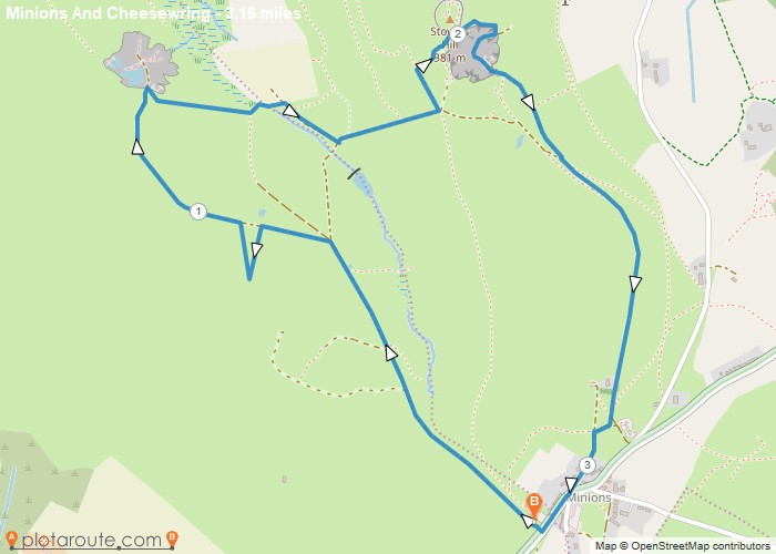
3.2 Miles circular walk from Minions via Cheesewring Quarry and Stowes Hill Walk 18 Cornish Teashop walks OS Maps Required
Distance: 3.2 miles
Starting Point: The Hurlers Car Park Grasmere Lane Minions Linkinhorne
Ending Point: The Hurlers Car Park Grasmere Lane Minions Linkinhorne
Terrain Type: Off-Road
Elevation: 1427 Feet
OS Map: OS Explorer
Walking Time: 1 hour 30 minutes
Interactive Map:
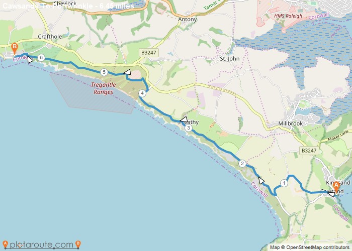
6 mile walk from Cawsands to Portwrinkle via South West Coast Path. Distance: 6.4 Miles Time: 3 hours 08 minutes
Distance: 6.4 miles
Starting Point: Kingsand
Ending Point: Portwrinkle
Terrain Type: Off-Road
Elevation: 463 Feet
OS Map: OS Explorer
Walking Time: 3 hours 08 minutes
Interactive Map:
Bramley
Favourite
5 mile walking route starting from Bramley following the disused railway to Cranleigh. Distance: 5 miles Time: 1.5 hours Elevation: 294 foot Terrain:
Distance: 5 miles
Starting Point: Bramley
Terrain Type: footpaths and tracks.
Elevation: 294 Feet
OS Map: OS Explorer
Walking Time: 1.5 hours
Interactive Map:
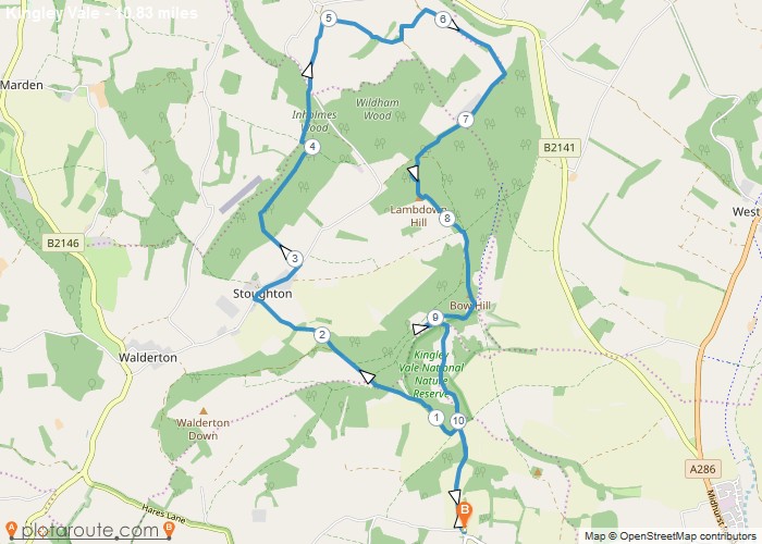
10.8 mile circular walk from West Stoke car park in West Sussex Distance: 10.8 milesTime: 3.5 hoursElevation: 400 footTerrain: footpaths
Distance: 10.8 miles
Starting Point: Kingley Vale Car Park West Sussex
Ending Point: Stoughton
Terrain Type: Downland ancient woodland and open hillside
Elevation: 400 Feet
OS Map: OS Explorer
Walking Time: 3.5 hours
Interactive Map:
NULL
Rowlands Castle
Favourite
6.2 mile circular walk from Rowlands Castle in Hampshire via Staunton Country Park and the Havant Thicket. Distance: 6.2 miles
Distance: 6.2 miles
Starting Point: Rowlands Castle Train Station Hampshire
Ending Point: Rowlands Castle Train Station Hampshire
Terrain Type: footpaths and tracks.
Elevation: 337 Feet
OS Map: OS Explorer
Walking Time: 2.5 hours
Interactive Map:
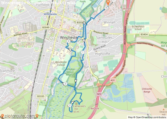
5 mile circular walk starting from Winchester via St Catherines Hill in Hampshire. Distance: 5 Miles Time: 1.5 hours Elevation:
Distance: 5 miles
Starting Point: Winchester Car Park
Ending Point: Winchester Car Park
Terrain Type: Riverside meadows and small hilltop
Elevation: 230 Feet
OS Map: OS Explorer
Walking Time: 1.5 hours
Interactive Map:
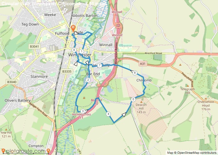
8.5 mile circular walk starting from Winchester via St Catherines Hill and Chilcombe in Hampshire. Distance: 8.5 milesTime: 3 hoursElevation:
Distance: 8.5 miles
Starting Point: Winchester Car Park
Ending Point: Winchester Car Park
Terrain Type: Downland river valley and urban paths
Elevation: 590 Feet
OS Map: OS Explorer
Walking Time: 3 hours
Interactive Map:
East Dean
Favourite
9.2 Mile Circular walking route starting from Eastbourne in East Sussex. Distance: 9.2 miles Time: 4 hours Elevation: 230 foot
Distance: 9.2
Starting Point: Eastbourne
Ending Point: Eastbourne
OS Map: OS Explorer
Interactive Map:
Circular Walking Trails
Favourite
3.7 Mile Circular Walking route from Hindhead in Surrey. Distance: 3.7 milesTime: 1 hoursElevation: 230 footTerrain: foot paths and tracks.Map:
Distance: 3.7
OS Map: OS Explorer
Interactive Map:
Circular Walking Trails
Favourite
4.1 Mile Circular Walking route from Farnham in Surrey. Distance: 4.1 miles Time: 1.5 hours Elevation: 230 foot Terrain: Coastal
Distance: 4.1
OS Map: OS Explorer
Interactive Map:
Circular Walking Trails
Favourite
A Circular walking route starting from Frensham Little Pond; Distance: 1.7 miles Time: 1 hours Elevation: 66 foot Terrain: footpaths
Distance: 1.7
OS Map: OS Explorer
Interactive Map:
England
Favourite
1.8 Mile Circular walking route starting from Frensham Great Pond in Surrey. Distance: 1.8 miles Time: 1 hours Elevation: 66
Distance: 1.8
OS Map: OS Explorer
Interactive Map:
England
Favourite
4.3 Mile Circular walking route starting from Frensham Great Pond via The Ham in Surrey. Distance: 4.3 miles Time: 1
Distance: 4.3
Starting Point: Frensham
Ending Point: Frensham
OS Map: OS Explorer
Interactive Map:
England
Favourite
3.2 mile circular walking route starting from Waverley in Surrey Distance: 3.2 miles Time: 1 hours Elevation: 236 foot Terrain:
Distance: 3.2
OS Map: OS Explorer
Interactive Map:
Circular Walking Trails
Favourite
5.8 Mile Circular walking route starting from Waverley inSurrey Distance: 5.8 miles Time: 2 hours Elevation: 636 foot Terrain: Coastal
Distance: 5.8
OS Map: OS Explorer
Interactive Map:
At a Glance
Walks available0 routes
DifficultyEasy to Moderate
Best monthsApril–October
TerrainGritstone moorland, reservoir, river valley, limestone gorge
CountyNorth Yorkshire
Dogs welcome✓ Yes
Getting There
Bridgehouse Gate car park in town. Bus from Harrogate (24)
Food & Drink
The Nidderdale Arms, Wildings Patisserie, Crown Hotel
Notable Walks Nearby
- Brimham Rocks
- How Stean Gorge
- Gouthwaite Reservoir
- Nidderdale Way
- Lofthouse & Middlesmoor
- Guise Cliff
- All North Yorkshire towns →
🗺 OS Map Reference
Walking around Pateley Bridge is covered by OS Explorer 298. Recommended for all routes in this area.
Long Distance Trails Nearby
- Nidderdale Way