Expand sub-categories
-
Avon1

-
Cheshire152

-
Cornwall874

-
Cotswold58

-
Cumbria2000

-
Derbyshire2697

-
Devon1936

-
Dorset765

-
East Sussex411

-
Essex66

-
Gloucestershire1206

-
Hampshire117

-
Kent639

-
Lancashire117

-
London159

-
Norfolk230

-
Oxfordshire105

-
Somerset273

-
Surrey219

-
West Sussex572

-
West Yorkshire1129


Loading...
No Records Found
Sorry, no records were found. Please adjust your search criteria and try again.
Maps failed to load
Sorry, unable to load the Maps API.
England
Favourite
Test Body 0 feet
Distance: Test Mile
Starting Point: Test SP
Ending Point: Test EP
Terrain: Test Terrain
Elevation: Test Elevation
OS Map: Test OS Map
Walking Time: Test Walking Time
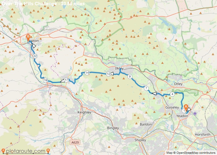
Distance: 23.9 Miles Time: 11 hours 03 minutes Elevation: 440 Feet Terrain: Off-Road Start Point: Yeadon End Point: Yeadon null
Distance: 23.9 Miles
Starting Point: Yeadon
Ending Point: Skipton
Terrain: Off-Road
Elevation: 440 Feet
OS Map: OS Explorer
Walking Time: 11 hours 03 minutes
Woodlesford
Favourite
Distance: 6.3 Miles Time: 2 hours 44 minutes Elevation: 95 Feet Terrain: Mixed Start Point: Woodlesford End Point: Woodlesford null
Distance: 6.3 Miles
Starting Point: Station Lane, Woodlesford
Ending Point: Station Lane, Woodlesford
Terrain: Mixed
Elevation: 95 Feet
OS Map: OS Explorer
Walking Time: 2 hours 44 minutes
Woodlesford
Favourite
Distance: 9.8 Miles Time: 4 hours 17 minutes Elevation: 817 Feet Terrain: Mixed Start Point: Woodlesford End Point: Woodlesford null
Distance: 9.8 Miles
Starting Point: Woodlesford
Ending Point: Woodlesford
Terrain: Mixed
Elevation: 817 Feet
OS Map: OS Explorer
Walking Time: 4 hours 17 minutes
England
Favourite
Distance: 5.7 Miles Time: 2 hours 31 minutes Elevation: 128 Feet Terrain: Mixed Start Point: Whitkirk End Point: Whitkirk null
Distance: 5.7 Miles
Starting Point: Station Lane, Woodlesford
Ending Point: Station Lane, Woodlesford
Terrain: Mixed
Elevation: 128 Feet
OS Map: OS Explorer
Walking Time: 2 hours 31 minutes
Wetherby
Favourite
Distance: 2.3 Miles Time: 1 hour 00 minutes Elevation: 853 Feet Terrain: Off-Road Start Point: Wetherby End Point: Wetherby null
Distance: 2.3 Miles
Starting Point: Parsons Green, Hallfield, Wetherby
Ending Point: Parsons Green, Hallfield, Wetherby
Terrain: Off-Road
Elevation: 853 Feet
OS Map: OS Explorer
Walking Time: 1 hour 00 minutes
